This photo arrangement includes elements from Washington State Department of Ecology documents and maps from Lewis County GIS.
I’m not a scientist. Making a volcano with baking soda and vinegar is basically the extent of my chemistry knowledge. Mrs. Davis and Mrs. Citro probably don’t remember me as a standout student in their environmental science or biology classes. But, as a “non-scientist,” I’ve been doing a little research.
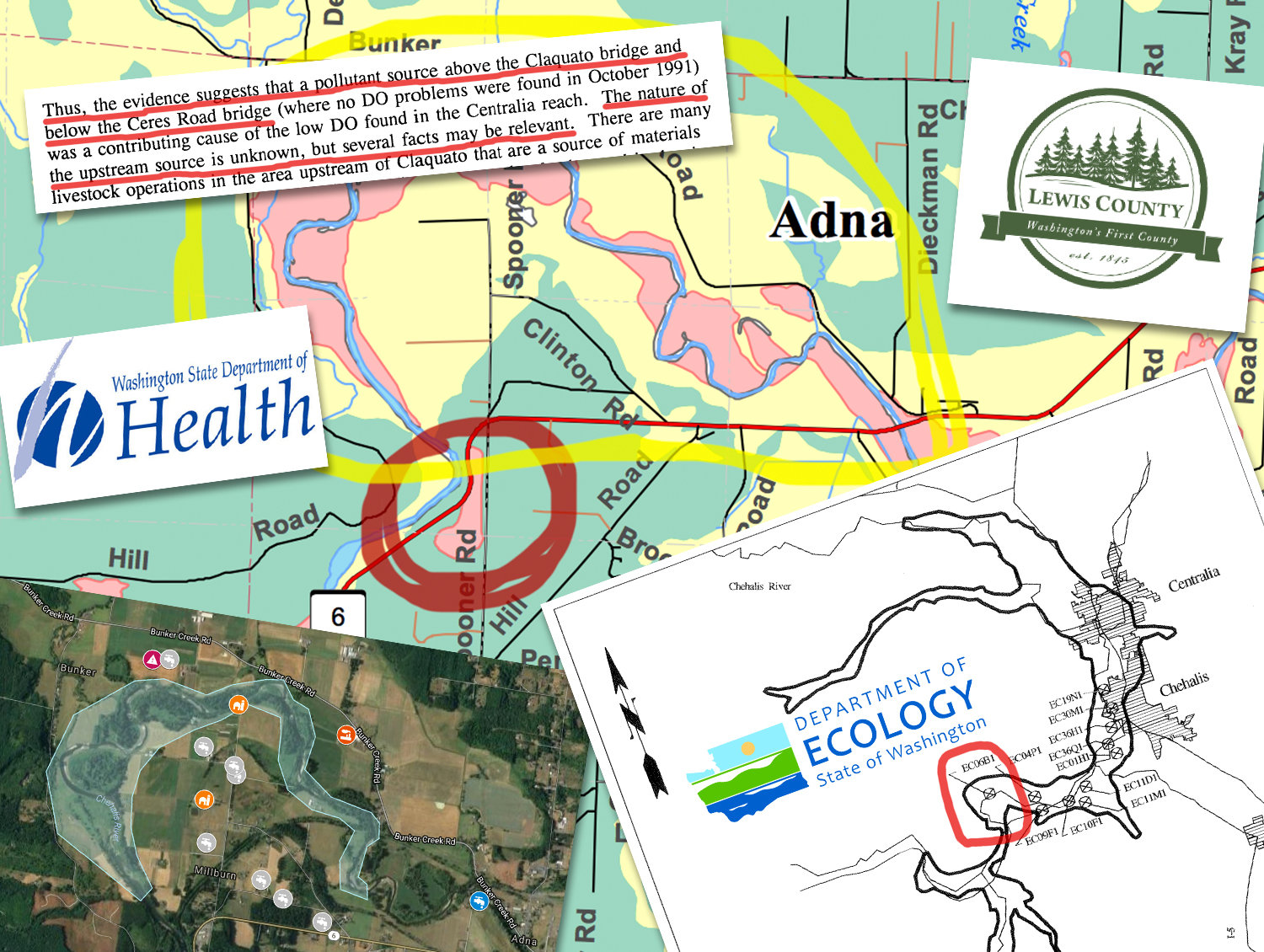
West of Chehalis, there’s a small neighborhood historically known as “Millburn.” The roughly 2.5 square-mile area is situated on a bend in the Chehalis River, between state Route 6 and Bunker Creek Road. Today, we know it as the Spooner, Clinton and Fay road area.
In that part of Adna, since the 1990s, there have been two instances of brain cancer in young men — a 21-year-old man who died in 2005 and another young man who is living with a brain tumor. Three people in the area also developed digestive tract cancers, including an immunocompromised Adna High School student who died his senior year. These cases occurred among people who lived within a mile of one another. And, these are only the cases I’m personally aware of.
I’m hesitant to call the cancer cases a “cluster,” but the array of cases has certainly given me pause several times, wondering if they are in any way connected.
Knowing that many residents in that area draw their water from private water wells, I started using the county’s GIS library to study aquifer maps that showed the groundwater supply in the area. I filed records requests with the county and inquired with two state agencies that deal with water quality: The Department of Ecology (DOE) and Department of Health (DOH).
While reading thousands of pages of documents and studies, I uncovered some potentially important information about local water quality that may have been overlooked back in the 1990s. Though more research and investigation is clearly needed, I believe high levels of a potential carcinogen in Millburn-area wells could offer one possible explanation for some of the cancers and other illnesses among residents.
This project also illustrated a troubling disconnect between state agencies that could be preventing researchers from seeing a complete view of how local environmental issues and public health could be connected.
I started building a digital map, plotting out the aquifer zones and locations of cancer cases. I also added registered wells. The government didn’t start tracking private well registration until the 1980s, so that data was limited.
I knew from growing up in the area that, decades ago, there was a landfill in the Millburn area, near the county shop on Spooner Road. Could this site be affecting groundwater? How was the site mitigated when the landfill closed? I filed requests with the the county and made phone calls to DOE on the topic.
While reviewing thousands of pages of DOE reports from the late 1980s on, one study stood out in particular: The 1994 East Chehalis Pesticide study, which measured the groundwater quality in nine drinking water wells and three irrigation wells along a stretch of the Chehalis River where agriculture was interspersed with homes.
Among other things, the study looked at the levels of nitrates in the water. According to DOH, nitrates are an “acute contaminant” that can be harmful to human health.”
According to the 2008 President’s Cancer Panel, “offspring of women in western Washington State who used private wells as their drinking water source during the pregnancy had a significantly increased risk of brain cancer”. The report noted that these risks were associated with the “highest nitrate category” — levels of 11 mg/L or greater.
Recent federal and university studies have linked excessive nitrates in rural water supplies to various health issues, including a possible association with some digestive system and brain cancers. The National Cancer Institute has also linked excessive nitrates in drinking water to certain types of cancer, including some digestive cancers. According to the CDC, high levels of nitrate in drinking water — which can come from poor well construction, overuse of fertilizers, and improper disposal of animal and human waste — can be especially dangerous for infants and pregnant women.
State water-quality standards say water should have less than ten milligrams of nitrates per liter (mg/L) of water. Overall, most sites in the study easily met the nitrates standard. Only three wells had detectable levels, and two of those were within safe limits. However, the well closest to the Millburn area had magnitudes more nitrate than the others.
The westernmost well in the study was on Bunker Creek Road, just across the river from Spooner Road. Called “EC06B1,” it supplied drinking water to seven homes (Group B) on Bunker Creek Road — and it shared an aquifer with Millburn.
In March 1993, initial samples from the site tested 14.5 mg/L. In August 1993, verification samples tested at 15.2 mg/L. By comparison, the site with the second-highest level had just 1.66 mg/L.
The researchers specifically pointed out that this site exceeded the 10 mg/L standard for public drinking supplies.
The DOH Office of Drinking Water tracks the quality of drinking water in wells that serve public facilities, as well as those that serve numerous households, and places like campgrounds and trailer parks. Their data about area wells doesn’t include the 1993 DOE test results. However, their own records also suggest that nitrate has been a persistent issue at the Bunker Creek Road site. According to DOH Office of Drinking Water records, a well at the same address as EC06B1 had a nitrate level of 10.5 mg/L as recently as July 2015.
A DOH database also turned up August 1994 documentation of nitrate levels that slightly exceed standards at the Lewis County Bunker Maintenance Shop, about 1.5 miles away from EC06B1. The county discontinued the use of the well at the Bunker Maintenance Shop in 2003, when they switched to Boistfort Water. A county official I spoke with on the phone noted the poor quality of the well.
We don’t have a complete picture of whether other wells in the area had similarly high levels, much less who was exposed or how often. Additionally, Boistfort Valley Water began serving some homes that had previously relied on wells, and many people have moved to, or away, from the area over the years.
Researchers at DOE started the “Nitrate Prioritization Project” in 2014, due to “growing concerns about groundwater contamination by nitrates, and the inability to display and evaluate nitrate data on a statewide basis.” So, that seemed like a good place start with my data.
However, when I contacted program staff in an email, they referred me to an epidemiologist at DOH.
During a phone conference with DOH, it was explained that state epidemiology professionals could not confirm that there was — or ever had been — a health issue in the Millburn area based on their available data. Their data did not indicate it. However, DOH also conceded that they couldn’t rule out a nitrate issue, because DOE doesn’t share data with DOH — they were missing the 1993 and 1994 test results from DOE, etc. — so they couldn’t claim to have a full, clear picture of data.
In Washington, DOH regulates wells that serve public facilities. Owners of wells that serve numerous homes or families — for example, small residential developments — have to test samples and submit results periodically. But there is little to no regulation of private wells. And DOE isn’t required to notify private well owners, even if they find a water quality issue in a shared water source.
“If you’re on a private water source, I’m sorry, you’re on your own,” the Epidemiology Manager explained.
To the best of my knowledge, the DOE did not share these results with anyone outside of their agency. It seems like a missed opportunity, because the DOH specifically cautions private well owners to test for nitrates at least once a year, and more often if levels are above 5 mg/L, saying nitrates “... rapidly could affect a person’s health — possibly even with just one drink of water.”
So, what caused those excessive nitrate levels? According to other DOE studies, such as the 1990s “Total Daily Maximum Load” (TMDL) study for the Chehalis River, it could have been agricultural runoff from local farms or fertilizer pollution. Or, possibly other indirect sources of waste, such as overuse of chemical fertilizers, or improper disposal of human and animal waste.
In all the reading and research, there’s one thing that never turned up: the old landfill near Spooner Road and State Route 6. A county records requests didn’t turn up any relevant records. It’s possible the landfill was closed before such things were regulated. I’m working to find out if DOE is even aware that a landfill existed at that location.
We can always ask “What if?” After all these years, it may not be possible to get definitive answers. But, I’m asking DOE and DOH: What will you do now to make sure data like this isn’t still falling through the cracks? Should residents have been notified, so that they could have made different health choices? And, what are you doing now to ensure that this aquifer area is not further impacted by a potential pollutant that could affect private well users?
Until the next update on the topic, if you live on Spooner, Clinton or Fay Road in Adna, and are on a private well — or private well all — please test your well for water quality, if you haven’t done so recently. Contact the Lewis County Water Laboratory for more information.
•••
Brittany Voie is The Chronicle’s senior media developer. She can be reached at bvoie@chronline.com.


