


More than 140 local fish and flood projects have been completed across the Chehalis River Basin, coordinated and funded through the Office of Chehalis Basin (OCB).
The OCB board is composed of local officials as well as tribal and environmental representatives.
These projects are done in cooperation with the Chehalis River Basin Flood Authority, local governments, tribes and the Aquatic Species Restoration team. Together, these projects are part of the Chehalis Basin Strategy to restore aquatic species and to reduce flood damage for families and communities.
This article is part of an ongoing series highlighting projects that have been completed in the basin. The Chronicle has partnered with the Office of Chehalis Basin for this series. Read previous installments at chronline.com.
Summary
A series of atmospheric rivers are expected to impact the Pacific Northwest beginning Saturday, Dec. 2. The National Weather Service is forecasting rising rivers and streams in the region. Some river locations in the Chehalis region may reach minor flood stage. Over the past month, rain gauges in the Chehalis River Basin have recorded 10 to 20 inches of rain with another 5 to 10 inches of rain possible by Dec. 4.
It’s time to be aware, and be prepared, with the Chehalis Basin Flood Warning System.
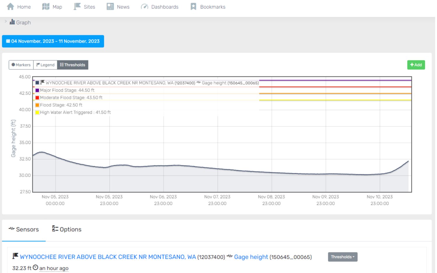
The Chehalis Basin Flood Warning System provides real-time data and information from a network of monitoring stations supporting improved flood forecasts and inundation maps to help Basin residents protect themselves and their property from potentially devastating losses.
The problem
Flooding is a fact of life in the Chehalis Basin, and climate change is intensifying its severity, according to the Office of Chehalis Basin. The Washington Department of Ecology notes: “Over the past few decades, peak seasonal flood levels have been rising — with five of the basin's largest historical floods occurring during the last 30 years.”
Major floods in the basin have resulted in evacuations, damage to homes and property, emergency rescues and even loss of life. The 2007 flood, for example, cost over a half a billion dollars in damage to private and public infrastructure in the Chehalis Basin and cost over $330 million statewide.
Floods also interrupt critical services and livelihoods. In 2007, Interstate 5, the main transportation channel for West Coast commerce, food supplies and public health, became impassable, which caused economic losses reaching far outside the Basin. Tens of thousands of people were left without power, farmers lost livestock, crops and feed inventories, and local hospitals ran on backup power.
The project
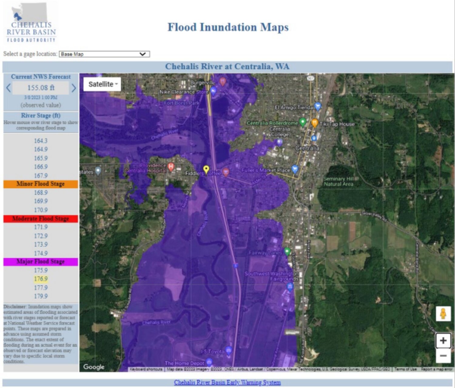
In 2010, the Chehalis River Basin Flood Authority authorized development of a flood warning system specific to the Chehalis Basin. The system was developed and designed to be a web portal with flood information to help Basin residents with flood preparedness decisions, and to provide improved data to support and leverage National Weather Service river forecasts in the Basin.
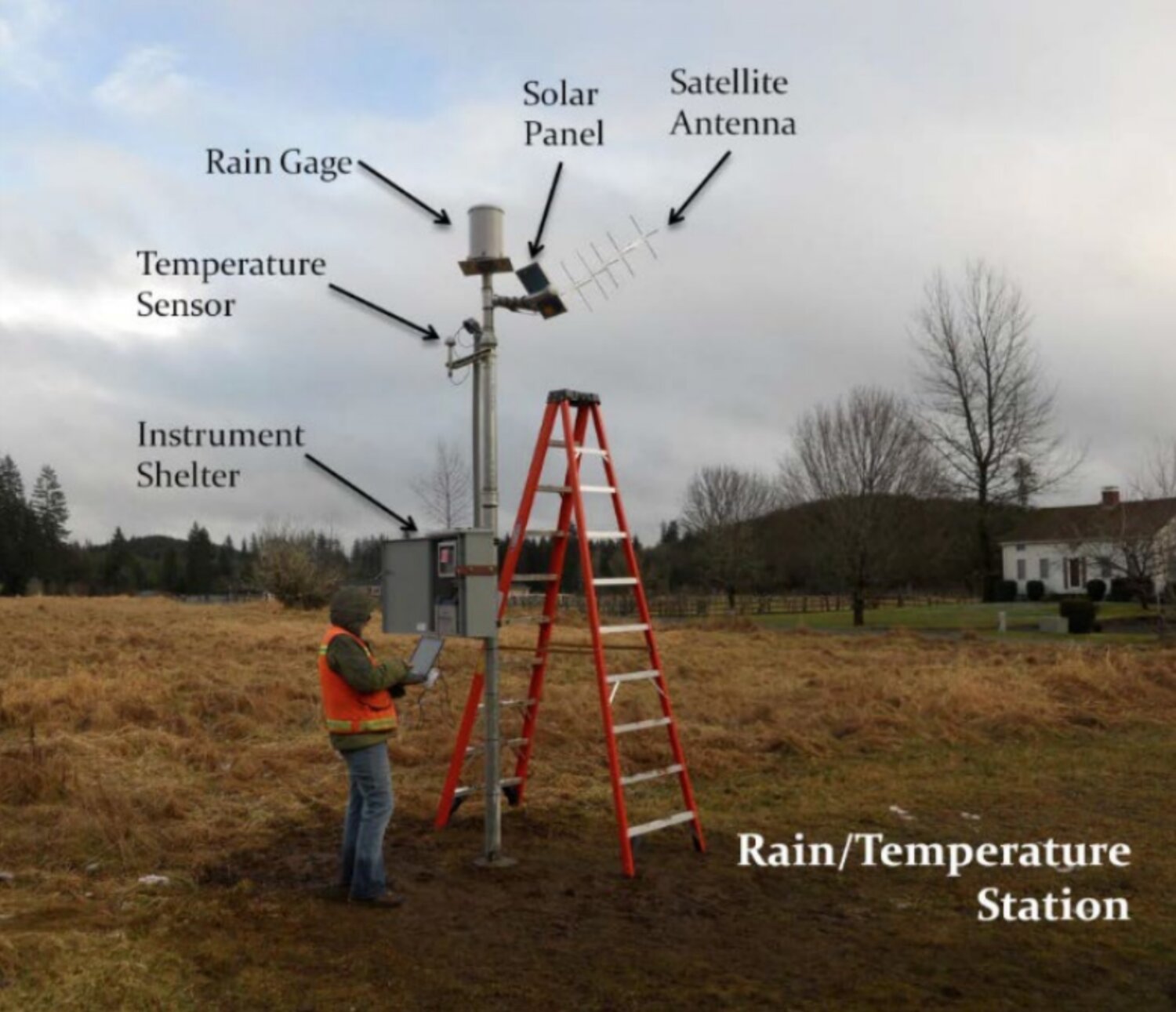
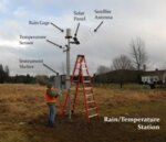
The Chehalis Basin Flood Warning System (FWS) (https://chehalis.onerain.com/) began with 22 new hydrometeorological sensors, including 10 rainfall, 10 temperature and two stream gauges. Connections were made to existing automated hydrometeorological monitoring networks in the region, adding about 100 sensors to the system, most reporting data in 15-minute increments.
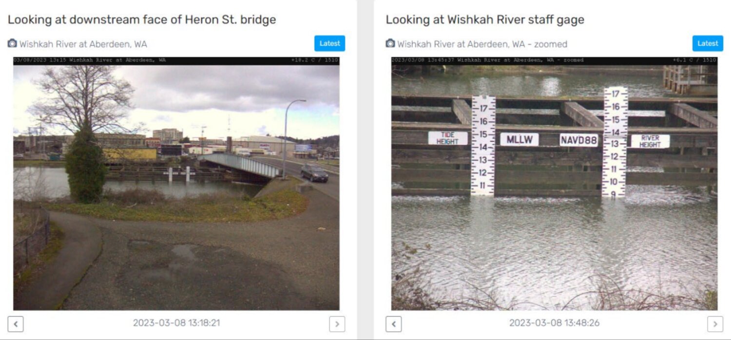
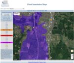
Each year, the FWS continues to improve and expand, with the goal of making the system more visible and useful to the community. Automated high water alert emails, webcams and improved inundation maps and visual presentations of important data are examples of significant recent additions.
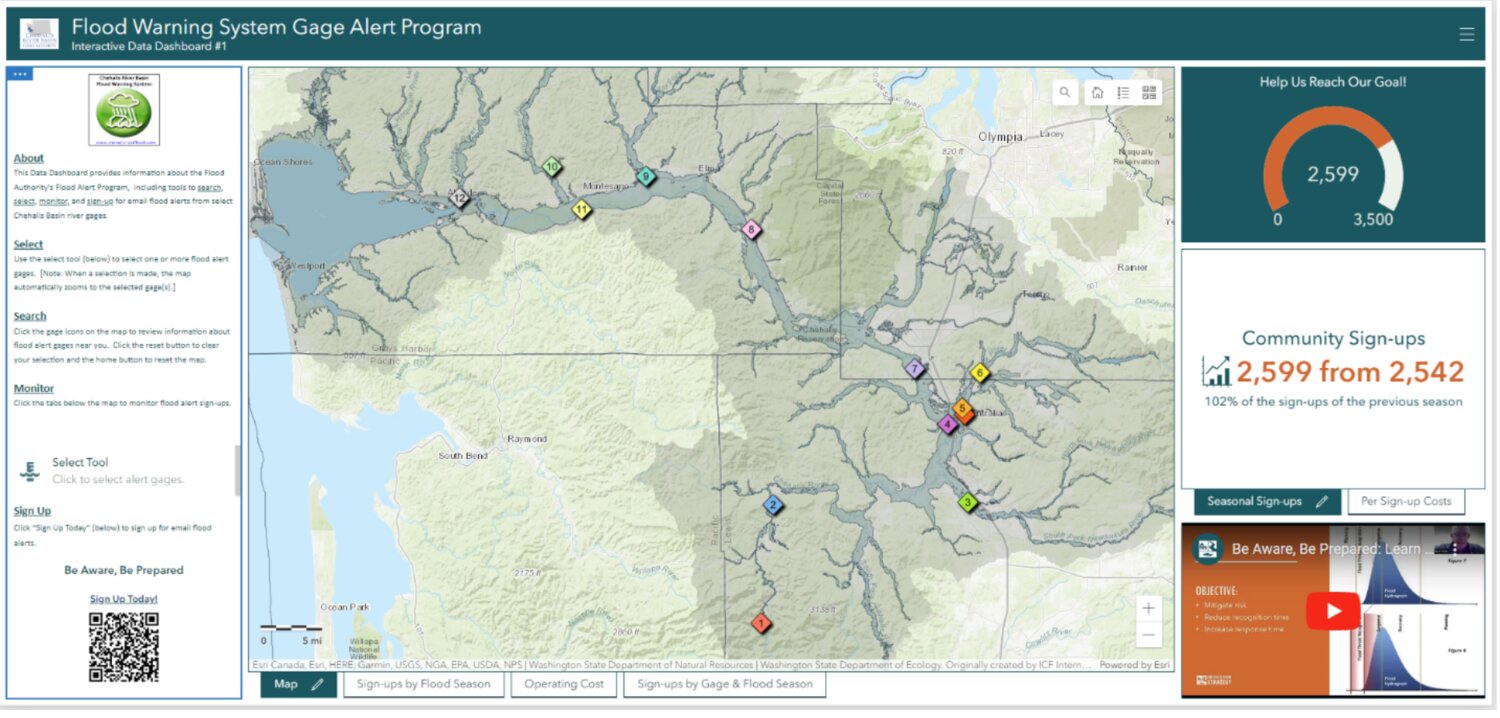
Email alerts from the FWS provide subscribers with advance warnings, giving them more time to respond to rising water levels. In the 2022-2023 flood season, there were over 2,400 new subscribers to the high water alert warning system.
All people and businesses who could be affected by flooding in the Chehalis Basin are encouraged to register for the 2023-2024 flood season email alerts (https://tinyurl.com/84bdnpcc). Participants can select to receive alerts from up to 13 different river gages across the Basin.
The Flood Warning System is a wealth of data. It leverages flood forecasting and related programs of the National Weather Service, the U.S. Geological Survey, the U.S. Department of Agriculture Natural Resources Conservation Service, and the Washington state departments of ecology and transportation.
Since 2016, the Office of Chehalis Basin (OCB) has partnered with the Flood Authority to fund the FWS, and has played a critical role in making the system what it is today: a leader in flood monitoring databases across the country. And, it comes at a fraction of the cost of other systems with similar functionality.
Grays Harbor County, Lewis County and Thurston County fund the FWS’ annual operation and maintenance. OCB and the Washington State Recreation and Conservation Office fund capital improvements.
The Flood Authority is the decision-making body overseeing the FWS. Flood Authority members include representatives from Lewis County, Oakville, Hoquiam, Centralia, Aberdeen, Cosmopolis, Pe Ell, Montesano, Bucoda, Grays Harbor County, Napavine, Thurston County and Chehalis.
WEST Consultants, especially Dr. David Curtis, have provided the technical knowledge and skill to design, install and maintain the Flood Warning System, distribute the data, and coordinate with interested parties.
The impact
The FWS’ forecasts, flood inundation maps, and high-water alerts are important to everyone living in the basin. In January 2022, record and near-record flooding returned to the basin. More than 25,000 unique logins to the FWS were recorded during the event, with approximately 73,000 visits to the flood inundation map pages from Jan. 6-7.
A post-event survey identified several potential system improvements that will be included in a new FWS master plan guiding capital expenditures for system improvements for the next five years.
At its biannual conference in June 2023, the National Hydrologic Warning Council (NHWC) recognized the Chehalis Basin Flood Warning System's outstanding sustained performance with the NHWC Operational Excellence Award. NHWC assists emergency and environmental management officials by providing expert advice, education and technical training on the generation and use of real-time, high quality hydrologic information from automated remote data systems, with the goals of protecting lives, property, infrastructure, resources, and to support the use of data to improve environmental knowledge and management. Recognition by the NHWC is a true testament to the dedication of the community to improve the flood safety and security of the region.
“This really is your system,” said Scott Boettcher, staff of the Flood Authority, during a November 2022 presentation on the FWS. “This dashboard and the Flood Warning System were originally funded by the state capital budget, but it’s really maintained by the local governments in the basin. So, the three counties and some of the cities, they pay the cost of maintaining this system."
Sign up to receive 2023-24 high water alerts from the FWS at www.chehalis.onerain.com.
ABOUT THE CHEHALIS BASIN STRATEGY
The Chehalis Basin Strategy is a network of partners and projects dedicated to protecting communities from flood damage, restoring critical habitat for aquatic life, and ensuring the Chehalis Basin is safe and prosperous for people, fish, and wildlife for generations to come.
The strategy, through the Office of Chehalis Basin, has invested nearly $152 million in on-the-ground flood preparation, flood damage reduction and aquatic species restoration, and has completed more than 140 projects, with dozens more underway.
The strategy is led by a group of representatives with diverse interests and perspectives called the Chehalis Basin Board and is administered and funded by the Washington Department of Ecology’s Office of Chehalis Basin. It depends on its many partners across the Chehalis Basin and the state to inform the path forward and take projects from ideas to reality.


