We visited a much different type of recreation trail last week, the Willapa Hills Trail. This is the "Rails to Trails" conversion of the old Northern Pacific Railway line that ran from Chehalis to South Bend.
The Washington State Parks and Recreation Commission purchased the right-of-way in 1993, removed the iron rails and ties, and designated it as the Willapa Hills Trail State Park. The total distance you could possibly travel on this trail is 56 miles. We managed to walk and mountain bike along a few miles here and there along the way.
The experience on this "trail" is as much a cultural and historical experience as a recreational one. The railroad passes through many communities on its way from Chehalis to the coast. Some of them existed prior to the railroad due to the attraction of the rich bottomlands of the Chehalis and Willapa River valleys to early settlers of Washington Territory. Others became towns after the railroad was built in 1892. Several of them no longer exist. But in the early 1900s, the area along the line bustled with activity and dreams.
Agriculture and logging dominated the economic landscape, and businesses that supported either of these sprang up all along the route.
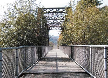
The entire length of the trail has been brushed, and the bridges across rivers and larger streams are all intact. The trail is open to horses, hikers, and mountain bikes. It is closed to motorized vehicles. Many gates and barricades have been installed at road crossings along the way to discourage motorized access. State Highway 6 parallels the trail and is nearby in many places, but parts of the trail are away from this and other roads. At times, they are on opposite sides of the Chehalis or Willapa Rivers from each other.
The only "completed" part of the trail runs from near Rainbow Falls State Park to Pe Ell, a distance of about seven miles. The trail between these points has been resurfaced and graded and a few information signs are in place along the way. A trailhead for this part of the trail is located near the center of town in Pe Ell. It includes parking, a picnic area and restrooms administered by Rainbow Falls State Park. There is a parking fee at the trailhead of $five per day, unless you have an annual State Parks day use permit, which costs $50.
Since there are so many road crossings along this trail, it is relatively easy to park at one of these and explore the trail sections that lead in either direction. We would recommend starting along the completed part of the trail. We mountain biked on the section from Dryad toward Pe Ell for a few miles and enjoyed it, although the trail surface is fairly rough in some areas and loose in others. You cross the Chehalis River on an old railroad bridge and later parallel the river for quite a distance.
In the lower reaches of the Willapa River, the trail provides access for fishing that is otherwise unavailable due to posted private land. These include the Oxbow region between Willapa and Menlo, the crusher hole near the mouth of Trap Creek, and that part of the river just west of Lebam.
Other areas that might be to fun to explore include the stretch from near the abandoned towns of Walville and McCormick (just west of the Chehalis River Crossing at Pe Ell), to Frances. This 10-mile stretch is mostly downhill and fairly steep for a railroad in places. You might want to consider taking two vehicles and leaving one near Frances, rather than walk or bike back uphill.
We think horses are probably the best bet for traveling long distances along the Willapa Hills trail, especially in its current condition. However you travel, keep in mind that this is not a scenic trail with distant vistas of peaks or landscapes. The things we found most interesting were very nearby and could easily be missed if you weren't paying close attention


