
Lewis County staff over the weekend published four map proposals that redraw the Board of County Commissioner district lines in accordance with new decennial U.S. Census Bureau data and redistricting efforts from the state.
The proposed maps can be viewed online at www.lewiscountywa.gov.
Lewis County commissioners will hold two public hearings — both at 10 a.m. on Dec. 14 and Dec. 21 in the meeting chambers — to hear feedback from the public about the proposals.
Later this month, one of the four maps will be selected by a vote of the county commissioners. The result will affect the next 10 years of representation and candidacy for the county's primary legislative body.
County Manager Erik Martin said the four maps were drawn by the county’s GIS office and were reviewed by his office prior to publication. In redrawing the boundaries by voter precincts, Martin said the office prioritized creating boundaries as equal in population and as compact as possible, per Washington state law.
“You keep it to a good shape. You don’t want to have a spider-shaped district out there,” Martin said.
Similar in guidance to the Washington State Redistricting Commission, the GIS office conformed maps to existing natural and geographical boundaries and attempted to keep communities of interest together. Per state law, the office was barred from drafting maps that favor any one political party or racial group.
“We want to keep voters who have historically been in one commissioner district in the same district as (much as) possible,” Martin said.
Looking at the maps, the effort of redistricting is narrowly focused on the precinct boundaries along the western portion of the county. East Lewis County residents — those living in Randle, Morton and Packwood areas — won’t have to fret at all about changes to their county representative.
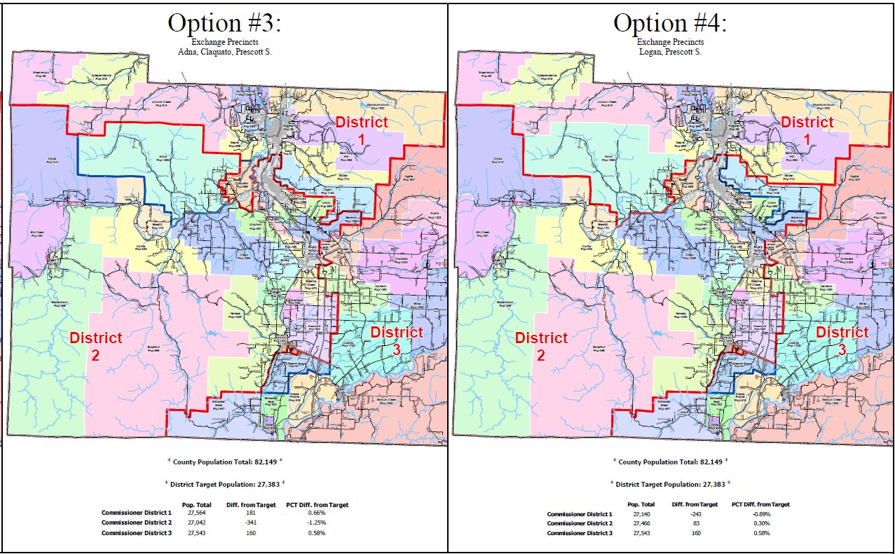
With a county population of 82,149, each of the districts should be as close to an apportionment of 27,383 as possible in order to ensure representation is proportional between the three districts.
Option No. 1 would leave the current boundaries as they are. Commissioner District No. 1 — which makes up Centralia and the northwest corner of the county, and is represented by Commissioner Sean Swope — currently has the largest population with 28,280 residents, about 897 more than it needs.
Both Commissioner Lindsey Pollock’s and Lee Grose’s districts are both currently below the 27,383 population target.
Commissioner District No. 2, the southwest district represented by Pollock, has a population of 27,093 and is about 290 residents short of the target. Commissioner District No. 3, the east county district represented by Grose, has a population of 26,776 and is about 607 residents short of the target.
Option No. 2 presented to the Board of County Commissioners would hand the Claquato precinct west of Chehalis from Pollock’s district to Swope’s in exchange for the Salzer and Logan precincts. Grose’s east county district would take Prescott South, located south of Winlock proper, from Pollock’s district.
Option No. 3 would exchange precincts in Adna, Claquato and Prescott South. Again, Prescott South would go to Grose’s district and Claquato would go to Swope’s district, but Adna residents, currently represented by Swope, would be drawn into Pollock’s commissioner district.
Option No. 4 would swap just two voter precincts. In this option, Prescott South would again go to Grose, but Pollock would pick up the Logan voter precinct located east of Chehalis proper.
Options 2 and 4 would bring all commissioner districts within a 1% population difference compared with the target — about 300 or so residents. In Option 3, though, Pollock’s district would have a population deficit of about 1.25% — about 341 residents — from the target.
No commissioners would be drawn out of their respective districts.
During a meeting on Wednesday, Martin detailed the procedural process of the hearings that will take place over the next two weeks. Commissioners at that meeting did not deliberate on any details or preferences of the maps, though it’s expected they will at upcoming public meetings.
Martin said the GIS office has done a great job in delivering the maps in a timely manner, especially after a snafu with the Washington State Redistricting Commission passing new legislative and congressional maps threw the county’s timeline into question.


