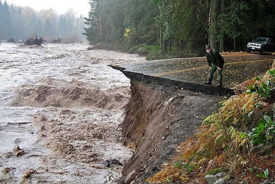
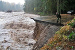
Mount Rainier National Park’s maintenance foreman Craig Hecht (now retired) watches a raging Nisqually River devour Sunshine Point Campground and the road to Longmire and Paradise during the flood of 2006.

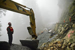
Mount Rainier National Park’s Stefen Lofgren left is framed by the massive arm of a excavator used to rebuild a critical section of the Steven’s Canyon Road that connects Paradise to the eastern side of the park that was washed out during the 2006 historic flooding. The road was repaired in 2007.

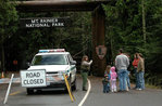
Mount Rainier National Park ranger Karen Ball, left, tells a family visiting from Minnesota that the park was closed. The park was closed for six months after the flood of 2006. It was the first closure for the park since the 1980 eruption of Mount St. Helens.
On Nov. 6, 2006, the skies opened and the Northwest’s oldest national park was forever changed.
For 36 hours it poured, dumping 18 inches of rain on Mount Rainier National Park. With the snow level at 10,000 feet, rain melted snow and loaded rivers and creeks beyond capacity.
Raging water washed away portions of roads, trails, bridges and other infrastructure. Landslides created additional damage.
The Carbon River Road was damaged beyond repair. Most of Sunshine Point Campground washed away. Access to Paradise was lost.
Visitors and employees were evacuated and once the gates were closed, they didn’t open again for six months. It was the longest closure in park history and the first since Mount St. Helens erupted in 1980.
“It is not unusual to have a road damaged over the course of the winter,” park superintendent Randy King said recently. “What was unique about this was that it was all over the park. Every watershed and the entire infrastructure. Every road, every trail.
“The scale of the flood and the damage was unprecedented.”
Ten years later, the park has mostly recovered. Roads and trails have been fixed or rerouted. And a legion of dedicated volunteers is one of the silver linings found among the devastation.
But there still is work to be done. There’s no winter car camping in the park. The Wonderland Trail remains damaged despite record use. And work continues in the Carbon River corridor in the park’s Northwest corner.
A little more progress is made each year, King said, but nature sometimes takes a bite out that progress too. Last winter, storms and flooding took out 100 trees in the Carbon River area.
“I don’t think anything is permanent when you are living on a volcano,” King said.
EATING AN ELEPHANT
How much rain is 18 inches? For comparison, consider the month that just passed.
In October 2016, records were set around the state. In Seattle, the National Weather Service reported the wettest October on record. 10.05 inches. In 31 days.
When 18 inches fell in 1½ days, it didn’t take long for the park to realize it had a problem and get visitors and employees to safety.
“We were anticipating a serious storm,” said King, who was deputy superintendent at the time, “but I don’t think anybody anticipated it being as bad as it was.”
By the time the Nisqually River undercut a building at Longmire and erased Sunshine Point and sections of road, visitors were evacuated.
King worked at Yellowstone in 1988 when forest fires torched more than a third of that park, so he was familiar with epic devastation. Still, he was surprised when the damage was tallied.
Putting the park back together was a daunting task.
“How do you eat an elephant?” King said. “One bite at a time.”
As misfortune goes, Rainier got lucky.
“If you have to close the park for six months, those are the six months you’d choose,” King said, referring to Rainier’s reduced winter visitation. “… With the closure, we didn’t have to worry about managing the park. We could focus on putting the park back together.”
SILVER LINING
The initial damage estimate was $36 million, but by 2007 that estimate was revised to $24-27 million.
The park saved money by completing work with staff rather than awarding contracts and by using alternative repair methods. But, it was a swell of support from the community that has had the most enduring effect on the park.
In a 2007 flood-recovery report, park officials said 1,724 volunteers contributed 84,038 hours of work in the year after the flood. It was a 96 percent increase in volunteers over 2006, and the contribution was valued at $1.6 million.
The infusion of volunteers helped lead to the creation of a full-time volunteer program manager. Ranger Kevin Bacher, who’d been coordinating volunteers in addition to his role as an interpreter, was promoted to the position that he still has today.
Doubling the volunteer base coupled with new partnerships with organizations, including the Washington Trails Association and the Student Conservation Association, has been a blessing for Rainier, Bacher said.
“Not only are those partners bringing in lots of people to volunteer, but they are continuing to support us,” Bacher said in July.
“A huge amount of people wanted to get outside, and suddenly they couldn’t do it anymore,” WTA interim executive director Rebecca Lavigne said recently. “And agencies didn’t have the funding to do it on their own. The WTA was one of a number of nonprofit and private businesses that stepped up to help. We recruited a lot of new volunteers. They saw we were doing important work and wanted to help.”
A decade after the flood, volunteers continue to turn out at a rate double what the park saw prior to the flood. In 2016, 2,000 people volunteered in the park, King said.
“You don’t want to have a crisis or a big incident, but, a lot of times, it brings out the best in people,” King said. “This was a good example of that.”
CONTINUED WORK
With Sunshine Point and vehicle access to Ipsut Creek washed away, winter car camping seems to be a thing of the past at Rainier, at least for now.
At Sunshine Point just inside the Nisqually entrance, King hopes the park can someday restore access to what remains.
There are big obstacles to clear. An access road would have a sharp turn and would likely need to go through wetlands. Then there’s the issue of the Nisqually River simply wiping away the campground again.
“We need to do an evaluation,” King said. “Can we reoccupy it? And, can we protect it?”
If shoulder season and winter car camping is to return to the park, the most likely location is in the Carbon River corner.
After the flood washed out the Carbon River Road in 2006, the park decided not to rebuild the 5-mile road to the Ipsut Creek Campground. Instead, the park is working to convert the road into a trail with access for cyclists.
This conversion costs an estimated $3 million.
“We don’t have $3 million,” King said.
So the park has chipped away at the project for the past decade. In 2017, work on the Ipsut Patrol Cabin, damaged in the flood, is expected to be completed.
But perhaps the most dramatic change in the park’s future is a boundary expansion in the Carbon River corner.
The park has already acquired 1,800 acres and moved the Carbon ranger station from the park entrance.
“Now, we’re trying to get funding to go through a planning process to discuss what kind of services should be provided there,” King said. “Do we want another campground you can drive into? Do we want to build something with bicycle access that ties into the Foothills Trail?”
King hopes to have funding for the planning phase and to start collecting public input within the next two years.
If the park is going to build a new campground, the boundary expansion area might prove to be the best bet for the location. Here, a campground can be built outside the floodplain.
The park is looking at a section of the Wonderland Trail between the Carbon Glacier and Ipsut Creek that has been closed since the flood. Hikers have been rerouted on another closed section of the old Carbon River Road.
“We’re taking a look to see if it is feasible,” King said of rebuilding the section of the Wonderland. “Ideally, we would, but it would likely require building new trail about 500 feet up the slope.”
Staying with the reroute is a viable option, too. The Wonderland’s route has changed several times over its 101-year history.
“We don’t want to be casual about it,” King said. “But there is a point when you have to accept what happened and realize the only feasible option is to think about a reroute.”


