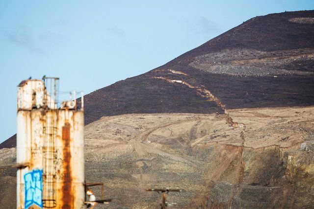
A crack in Rattlesnake Ridge south of Union Gap, Yakima County, seen Wednesday, has been growing and has prompted evacuations of nearby residents and the closure of Thorp Road. Geologists say the situation will result in a landslide, and rockfall in the area has been reported
UNION GAP, Yakima County — The moment Amanda Thomas saw the drone videos of fissures slicing across the flank of Rattlesnake Ridge, she knew she had to study the slumping hillside near Yakima.
“I thought: ‘Wow! This is amazing,’ ” said the University of Oregon seismologist. “Then I got on the phone.”
Thomas got the OK to deploy a cutting-edge array of tiny seismometers that have been recording the pops and creaks produced as a 4 million-cubic-foot chunk of rock and dirt pulls away from the slope and creeps downhill in a slow-motion landslide.
“It’s an incredible opportunity to see this slide evolve right before your eyes,” she said. “There’s a lot of cool science that can be done here.”
Thomas isn’t the only one who thinks so.
Researchers from across the region are using Rattlesnake Ridge as a natural laboratory to observe a landslide in action and test new approaches to understanding and monitoring unstable slopes. Their common goal is to develop better ways to identify and evaluate slide-prone hillsides — and perhaps even predict when they are about to let loose.
“There is an opportunity to turn this unplanned event into a real benefit for landslide science,” said Jeffrey Moore, an engineering geologist at the University of Utah.
Since the cracks were first seen in October, the 800-foot-tall hill has been under constant scrutiny. The ridge, which looms over Interstate 82, a rail corridor and the Yakima River, was blanketed with conventional surveying tools to measure how fast it was moving and in which directions.
In mid-December, when the hillside started slipping faster, engineers hired by a quarry at the base of the slope warned that a major collapse could occur as early as January. Residents were evacuated from nearby homes.
Fears of a catastrophic slide have since eased. The slope is no longer accelerating, but it is chugging downhill at a constant rate of about 1.7 feet per week. The most likely scenario, experts say, is that it will continue moving slowly — perhaps for years — sloughing off occasional rockfalls and eventually slumping into the quarry pit.
Keeping Watch
Science at Rattlesnake Ridge has always been secondary to monitoring for public safety, but researchers are contributing to those efforts as well.
University of Washington emeritus professor Steve Malone and colleagues at the Pacific Northwest Seismic Network (PNSN) installed five standard seismometers on the hill and are listening for any quickening of tremors that might presage a slope collapse. A group from the University of Oregon installed two high-resolution cameras, designed for spotting forest fires and equipped with night vision, to keep a constant watch on the ridge.
UW geophysicist David Schmidt and his team have been taking periodic “snapshots” of the slide with a unique radar instrument that can detect millimeter-level movements over a much wider swath of ground than old-school survey methods.
“There’s obviously a major concern about this ridge, and if we can contribute information to the decision-makers, we want to do it,” Schmidt said.
Like all the other scientists, he’s also eager to gain new insights.
Schmidt’s tripod-mounted instrument, called a ground portable radar interferometer, is one of only about 20 in the world. It works by comparing radar echoes over time to detect minute ground motions. This is the first time Schmidt has used it to scan a landslide, but he thinks the technique has potential for rapid appraisal of other potentially dangerous slopes — from a comfortable distance.
“We can throw it in the back of a truck, head out to a site and quickly assess the situation and whether it’s safe for people to be around,” Schmidt said.
Long-term radar and seismic observations from Rattlesnake Ridge will help researchers understand the mechanics of the slide and how it behaves, the scientists say. Then when a similar slope starts acting up in the future, those observations can serve as a baseline for comparison and forecasts.
Scott Henderson, a postdoctoral researcher who works with Schmidt, is monitoring slide motion, too — but without having to leave his office at the UW. He relies on the Sentinel-1 satellite, which sweeps over Rattlesnake Ridge every 12 days, sending out pulses of radar and capturing the reflections.
“It’s exciting,” said Henderson, who processes each new batch of data as soon as it comes in. He’s also able to peer into the past. While cracks weren’t spotted on Rattlesnake Ridge until October, the spaceborne radar shows that the hill was already shifting in early spring.
The technique, called InSAR (interferometric synthetic aperture radar), is often used to detect the slow inflation of volcanoes as they fill with magma. Landslide monitoring is a newer application, and Schmidt and Henderson are working to fine-tune it.
Henderson’s goal is to develop an automated system to churn through vast amounts of satellite data and identify hazards, like unstable slopes, at an early stage.
Before the 2014 Oso landslide in Snohomish County killed 43 people, some residents noticed cracks in the bluff. But the slope was not being monitored and the collapse came without warning.
After Oso, Washington Sen. Maria Cantwell and others introduced a bill to create a national landslide hazard-reduction program that would inventory dangerous slopes and expand monitoring, but the measure hasn’t passed.
“There are many other hills in Washington where there are no instruments,” Henderson said. “InSAR could eventually be a huge asset for landslide monitoring.”
A 3-D Picture
Seismologists like Thomas are trying to figure out what’s going on inside the landslide by listening to it.
The five traditional seismometers — with their solar panels, car batteries and tubs full of electronics — stream data constantly, but are also expensive and time-consuming to install and maintain. Thomas’ soup-can-size instruments, called nodes, cost a tenth as much. She and her team were able to install 38 in a day.
“It’s a technology at the frontier of seismology,” Thomas said. “It literally takes five minutes to deploy these stations.”
On a recent visit to swap out instruments on the ridge, Thomas demonstrated, kneeling and scraping at the frozen ground with a spade. She uncovered an instrument buried a few weeks before, yanked it out and inserted a fully-charged replacement in the hole.
“That’s all there is to it,” she said, wiping the dirt off her gloves and moving on to the next site.
The nodes can’t transmit live data, but can store 30 days’ worth of recordings that Thomas and her team download in their lab.
Having more than 40 seismometers on a landslide is unprecedented and allows scientists to pick up the faintest snaps and pops, and pinpoint where they’re coming from, Thomas explained. The result is a kind of 3-D picture of the quarter-mile-long chunk of hillside, where it’s fracturing and how it’s lurching downhill.
The possibility that seismic signals could provide early warning of landslides got a tragic boost last summer, when a towering slope collapsed in Greenland and triggered a 300-foot-high tsunami that killed four people. The closest seismometer was nearly 20 miles away, but it recorded a drumbeat of little earthquakes hours before the slope failed.
“That’s what we would expect from a landslide slipping — very repetitive, tiny, tiny events,” said Western Washington University geologist Jackie Caplan-Auerbach, who spotted the precursory quakes in Greenland and has been poring over the seismic tracings from Rattlesnake Ridge.
If the pattern holds true for other slopes, it might be possible to train computers to sort through seismic data from across the region for signs of impending landslides, Thomas said.
Moore, of the University of Utah, is testing another approach to slide prediction — which required a bit of bravado to pull off.
He suspects that subtle changes in the way a landslide mass vibrates as it shifts and fractures could be a red flag that collapse is imminent. But to capture the faint vibrations, he needed a seismometer positioned right on top of the Rattlesnake Ridge slide mass, a treacherous area with yawning fissures and a crumbling scarp that the researchers had avoided.
Two PNSN field engineers volunteered to do the job — quickly.
They buried the instrument and strung a 200-foot cable connecting it to a data logger and power source on more stable ground. If the slope eventually tumbles, the seismometer will be lost, but the rest of the gear should survive.
Whether the slide moves slowly or shifts gears and tumbles in a rush, researchers are well-positioned to document the process and gather invaluable data. The survey measurements collected by contractors and state agencies are another ongoing treasure trove of information for landslide experts, one of whom described Rattlesnake Ridge as one of the “best documented slides” he had ever encountered.
It was actually a relief when the slide stopped accelerating, Moore said. “A bit of a slower pace helps careful scientific analysis, and if things speed up, we’ll be ready.”
If the hillside continues to move for years, he even envisions it serving as a kind of “landslide observatory.”
“This site is generating so much great data that it will help us refine our methods and understanding of landslide behavior and, ultimately, manage the risk associated with large landslides,” Moore said. “We’ll just keep learning and learning and learning the more we get to work on it.”


