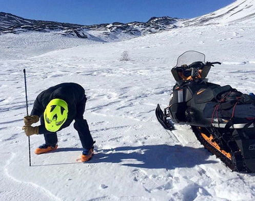
A courtesy photo from Oregon State University shows how citizen scientists can help NASA record snow depths across the Northwest.
The National Aeronautics and Space Administration typically spends its time looking out toward the edge of the universe for signs of water and the like, but a new project will have the space agency turning around for a look at snow here on earth.
Instead of astronauts, NASA is seeking the assistance of adventurous citizens to gather the required data for a study intended to generate computer models that will calculate the quantity of snow stored away on Pacific Northwest mountains. That information, known as snow-water equivalent, will be used to help scientists, engineers and land and watershed users to make informed decisions in the future.
Specifically, NASA is seeking the assistance of skiers, snowboarders, snow-machine operators and mountaineers to report their findings from around various regional peaks. The project is part of NASA’s Citizen Science for Earth Systems program and is known as Community Snow Observations.
The NASA-funded project will last four years with assistance form Oregon State University civil engineering professor David Hill and Ph.D. student Ryan Crumley. Researchers from the University of Washington and the Alaska Division of Geological and Geophysical Surveys are also involved.
“Our initial model runs show that the citizen science measurements are doing an amazing job of improving our simulations,” said David Hill, of the OSU College of Engineering, in a press release. “NASA has an unbelievable number of satellite assets in the sky producing incredible information about what’s going on in the earth’s systems, and they’re leveraging information and expertise from the public to make their product even better.”
In order to report observations for the study, citizen scientists need only an avalanche probe with measured markings and a smartphone with the free Mountain Hub application. Using those tools, multiple snow depths can be uploaded to the app from various points on a day’s adventure.
“Traditionally, the types of models we run have relied on ‘point’ measurements, such as snow telemetry stations,” Hill explained. “Citizen scientists who are traveling in backcountry snow environments can provide us with much more data than those stations provide.”
The Community Snow Observations project began in February but has so far focused primarily on Alaskan snowpacks. Researchers are hoping to enlarge the scope of the project to high altitude points from the Rocky Mountains to the Olympics. The Cascade Mountain range rises in the heart of the project’s range.
Based on the nature of the study, the specific areas of study will largely be up to public participation. Researches say the model will work best if they receive multiple points of data over a long period of time.
“The models take into account the temporal densification of the snowpack and the spatial variability in snow-water equivalent and how snow properties are always changing, even in a given location,” Hill said. “If we get a whole bunch of measurements on one day in one spot, that has value, but the more we can get things stretched out, the more coverage we get, the better modeling products we can produce.”
Additional information is available online at communitysnowobs.org.


