When the U.S. Corps of Engineers decided a new fish release was needed on the North Fork Toutle River, the first step was to survey the location. Traditionally, this would mean hours of crew time, hiking, sketching and measuring.
The Washington Department of Fish and Wildlife (WDFW) offers an easier way: drones.
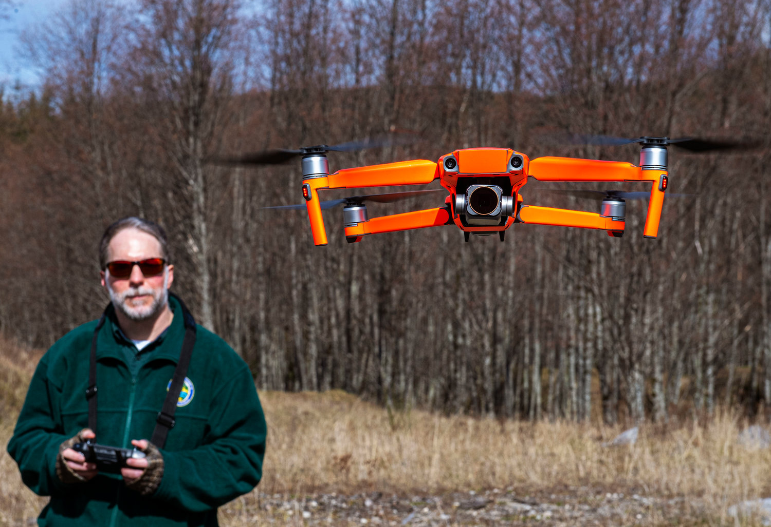
“You can fly the machine in and get what you need to get in a half-hour to an hour, and a crew could take all day and experience some risk that might not be necessary,” WDFW biologist and licensed drone pilot George Fornes said.
Fornes had gone to scope out a potential location near Deer Creek, in the Hoffstadt Unit of the Mount St. Helens Wildlife Area, with other WDFW staff and Corps staff. They started talking about how the flood plain connected to other creeks and fish spawning habitat higher up, as it affects the suitability of the site.
“We just wanted to know what the status was,” Fornes said. “People started talking about hiking up and maybe taking a look and at that point I just threw it out there, what if I flew the drone? I could get airborne and spend some time flying. Spending half an hour in the air would answer most of these questions.”
That’s exactly what Fornes ended up doing. In January, he returned to the site and took several hundred air photos he later combined into one composite air photo with a stunning level of detail compared to both Google Earth satellite imagery and more traditional methods.
“You can see braided channels, that there are side channels are coming in, you can start to pick out sediment size and pieces of wood, you can tell what series of trees are in the land around the river, you get all this information just for minimal amount of work, really,” he said. “A picture tells a thousand words, and there’s a ton of information you can get out of this that speaks to the habitat we’re trying to open up access to.”
Legacy of 1980 Eruption
The new release site is part of the Corps’ Long-Term Sediment Management Plan, which lays out the work in the area through 2035. When Mount St. Helens erupted in 1980, a vast amount of sediment flowed down its rivers, the North Fork Toutle River included. Those rivers still are full of sediment today, which increases downstream flood risks.
In 1985, the Corps built a sediment retention structure to catch the sediment and reduce the flood risk to the downstream communities along the Cowlitz River.
Fornes said while the retention structure is working, it also created an obstacle for endangered fish, mostly salmon, that were trying to move upstream to spawn. The Corps built a fish collection facility upstream where the Green River meets the Toutle to mitigate the blockage.
WDFW captures fish that get stuck at the retention structure, puts them in tanker trucks and drives them around the blockade. Currently, there are two fish release sites in the area, one on the north side of that sediment plain at Bear Creek and one on the south side at Alder Creek.
Chris Gleizes, a WDFW biologist who works at the fish collection center, said the current locations staff have to hand-dip each individual fish out of the tank and then drop them into small flumes, or tubes, that spits them farther out into the river.
The proposed new site would have a structure that would allow Gleizes and his crew to drive up and release the fish straight from the tanker truck into a V-shaped structure that would funnel the fish into a pipe that extends out into the creek.
“You could just pull the gate on the back of the tank and let water and fish all go at once,” Gleizes said. “It’s less fish handling, so less stress on the fish.”
A third site would also allow the fish more range into their natural habitat, where they used to spawn before the eruption and the retention structure.
“This additional release site just opens up more available spawning habitat for coho and steelhead both, and potentially a reintroduction of even fall Chinook into the upper Toutle River in the foreseeable future,” Gleizes said.
While the fish still wouldn’t be harvestable by fishermen, Gleizes said at this point it’s more about the intrinsic value of having salmon in the Toutle River.
WDFW Habitat Program Manager David Howe added “the more that we allow them access to their historical habitat, the closer we get to potentially delisting some of these runs” from the endangered species list.
“When we can delist them, there’s even more recreational opportunity when it comes to fishing,” he said. “So this gets us one step closer.”
Drones and WDFW
WDFW flew its first drone in 2017, and since then has used them for everything from counting moose and rabbits to monitoring restoration projects. Fornes said he expects uses will expand as more people become familiar with drone technology and as processing software improves.
In the case of Deer Creek, using a drone “saved on-the-ground crews in waders who knows how much time trotting around up there trying to figure out how it was all intertwined,” Fornes said.
If Fornes hadn’t used the drones, crews would have driven out to the remote site and spent hours hiking the area, making sketches and taking certain measurements. With drone imagery, Fornes was able to stand on the sediment plain and get photos with such high resolution that researchers can make “an infinite amount of measurements” and revisit the photos for any number of projects.
Even helicopter imagery doesn’t compare, Fornes said, because while the images may be sharper than something like Google Earth, a helicopter flight is expensive and putting a crew in the air creates an unnecessary risk.
Howe said “there’s no question that this is more efficient than what a ground crew would be able to produce,” adding that drones allow scientists to be more effective, and that will only continue as they “continue to understand the capabilities and technology.”
For example, Fornes said there is software available that takes drone photos and creates a three-dimensional model, like a land survey, that can be easily repeated to monitor sediment movement. Other software can be trained to recognize and count specific objects, like logs or sharks, freeing up researcher time.
“The actual imagery collection is one thing, but the science is moving forward really rapidly on what you can get from that imagery,” Fornes said. “That kind of use is only going to increase as we move forward with these things. Who knows what we’ll be able to do with them five years from now?”
As with any tool, there are drawbacks. For example, Fornes said the composite image struggled to stitch some of the photos in, so while they can be viewed separately, they’re not in the composite.
There are also strict Federal Aviation Administration regulations stating who can fly drones and where they can be flown. Fornes had to be licensed to fly the drone and must submit flight plans before surveying Deer Creek.
Howe said WDFW also is sensitive to privacy concerns, so they notify the public before they fly and only fly in areas where they have permission from everyone involved. Fornes added that WDWF created a drone policy of its own, to make it “very clear we’re going to respect privacy and be transparent when it comes to what we plan to use them for.”
The Future of Deer Creek
Fornes said he “collected what I set out to collect” and now the Corps will start planning and building based on the data WDFW collected from the drone flight.
While Fornes’ “piece of it as a drone pilot is wrapped up,” the close partnership between WDFW and the Corps will continue, both on the ground and in the air.
“We’ve been working together and trying to figure out the best path forward for years,” he said.


