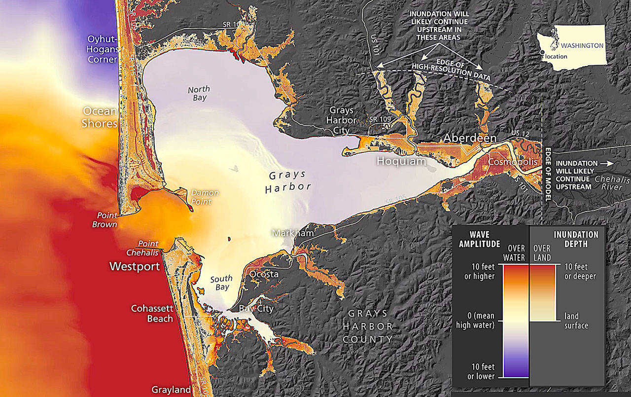
COURTESY DEPARTMENT OF NATURAL RESOURCES The newly-released Grays Harbor tsunami inundation video here shows water levels about four hours after a Cascadia subduction zone 9.0 earthquake. The colors range from light yellow - little inundation - to red, which represents 10 feet or more inundation depth.
A new series of tsunami inundation simulations for Grays Harbor and Willapa Bay was released Monday by the state Department of Natural Resources, showing the estimated height and speed of waves following a magnitude 9.0 earthquake on the Cascadia subduction zone.
“The videos demonstrate estimated tsunami wave arrival times following the earthquake and either detailed localized tsunami amplitude and inundation or current velocity (wave speed) for the coastal areas along Grays Harbor and Willapa Bay,” said Washington Geological Survey tsunami geologist Alex Dolcimascolo.
The less than three minute video simulations demonstrate how the tsunami wave heights change throughout the entirety of the tsunami event, increasing and decreasing over a span of about eight hours.
The Grays Harbor video shows inundation levels east to Cosmopolis. About an hour after a 9.0 quake, Westport, Ocean Shores, Ocosta, Hoqiuam and Bowerman Airport are seeing several feet of inundation.
An hour later, another major surge hits with deeper inundations reaching into Aberdeen and Cosmopolis. Surges continue and five hours in, portions of Hoquiam, Aberdeen and Cosmopolis could see inundations of up to 10 feet or more. The video ends just short of eight hours after the quake and shows in detail heavy inundations in Ocosta, Markham and portions of Aberdeen and Hoquiam.
Willapa Bay videos are broken into two separate presentations, north and south. The north map includes Tokeland and North Cove, Raymond, South Bend and Bay Center. The south map shows Ilwaco, Naselle, Long Beach and Ocean Park. Eight hours after a quake all of those areas can see inundation of up to 10 feet or more, higher along the immediate coast and upriver channels.
These simulations are designed to give emergency planners and communities the best possible visualized information about tsunami impacts and timing so they can plan accordingly, according to a Natural Resources statement.
“Tsunamis have struck Washington’s coast many times over our geologic history. It’s a question of when, not if, the next one will hit,” said Commissioner of Public Lands Hilary Franz. “These videos are designed to give the communities that would be most impacted by tsunamis a visualization of what areas are likely to face the most damage so they can make sure their residents, businesses and institutions are secure and resilient.”
All these simulation videos are available on the Natural Resources YouTube channel at https://www.youtube.com/playlist?list=PLKpn_ilWjh51SEKRBO9mFJx688fjzYkJm.
More is available on the DNR tsunami web page at https://www.dnr.wa.gov/programs-and-services/geology/geologic-hazards/Tsunamis#tsunami-simulation-videos.
320 years since Cascadia last quaked
The last magnitude 9 Cascadia subduction zone earthquake struck in 1700 and produced a tsunami that left sand deposits and drowned forests, which can still be seen in places like the Copalis Ghost Forest in Grays Harbor County. The geologic record shows the Cascadia subduction zone – the offshore area where the Juan de Fuca tectonic plate pushes under the larger North American plate – produces megathrust quakes every 300 to 600 years, according to Natural Resources. There have been about 40 earthquakes on the subduction zone in the last 10,000 years.
More tsunami information available online
The video simulations add to the suite of tsunami preparation materials developed by the geologists within DNR’s Washington Geological Survey.
More detailed maps of tsunami hazards, along with evacuation maps, preparation tips and additional information about these simulations are available online at https://www.dnr.wa.gov/tsunami.
Preparation
The state Emergency Management Department (EMD) is hosting a preparedness webinar Thursday, Sept. 17 at 11:30 a.m.
“For National Preparedness Month in September, EMD is partnering with a few local jurisdictions in a two-part webinar series titled Re-Prepare,” said EMD Tsuanmi Program Coordinator Elyssa Tapero. “The purpose of these webinars is to encourage everyone to re-evaluate their preparedness, review their family plan, and re-stock their disaster kits.”
Even in times of the pandemic, an emergency kit can often be put together with items already in the home. The webinar will cover that, and include mental and emotional resiliency, identifying home hazards, and how to talk to others about disaster preparedness.
The link to the free webinar is https://bit.ly/re-prepare2.


