The floating log mat of Spirit Lake, left behind after the May 18, 1980, eruption of Mount St. Helens can be clearly seen from the Windy Ridge viewpoint.
It may be the most studied landscape on our planet.
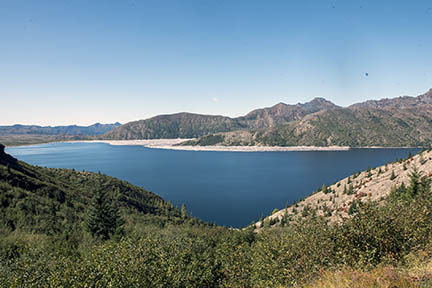
In all, 33 research projects covering hundreds of acres continue on the south shore of Spirit Lake, the area at the foot of Mount St. Helens where nearly all life was obliterated on the morning of the volcano's eruption on May 18, 1980. It is still largely barren, but biologists are finding new species and an expanding array of returning plants, birds and microscopic life.
They span a wide range of ecological inquiry: How are soils developing? How are streams evolving? How fast are frogs, salamanders, fish and other aquatic species colonizing them? What kinds of birds, insects and mammals have returned? In short, how is nature rebuilding a complex web of life in a ravaged land?
In the name of public safety, though, at least some of these research projects may be damaged or compromised under a proposal to build a dirt road across the area, known as the Pumice Plain. Researchers -- some of whom have spent their whole professional lives studying the area -- fear the road and drilling will trash research plots, introduce invasive plant species and invite illegal use of the area.
The U.S. Forest Service wants to re-establish a 3-mile, 8-foot-wide route from Windy Ridge down to the southwest corner of Spirit Lake to support operation and maintenance of the Spirit Lake drainage tunnel, the 1.6 mile-long conduit bored out from rock under Harrys Ridge that controls the lake's level. The Forest Service says it needs the road to bring in heavy drilling rigs to collect borehole data to determine the safety of the debris blockage holding back the lake. The re-established road would follow the course of an early 1980s road used to service the lake-pumping operation that preceded construction of the drainage tunnel.
The stakes are high for the scientific community and for the safety of Longview, Kelso, Castle Rock and other communities that live downstream of the lake. Studies undertaken nearly four decades ago concluded the lake would cause catastrophic damage through the Toutle, Cowlitz and Columbia rivers (as far as Portland) if it were to breach the debris blockage. At the time, the lake was compared to the mythical Sword of Damocles, ready to smite the community with a massive flood.
Even though both sides say there is room for compromise, the stakes are high for a land-use decision: Protecting world-class research versus protecting more than 60,000 people who live downstream.
But there also are a couple subplots at play, too. Scientists fear opening the lake to even limited motorized use will increase pressure to open the area to the public, contrary to the letter and spirit of the 1982 law creating the Mount St. Helens National Volcanic Monument, which set aside the area primarily as a preserve for research. In addition, there is some fear the Forest Service might use the data to build a new, surface channel into the lake, a project that could have geological risks and ecological consequences and that was rejected 35 years ago.
There's passion on both sides.
"As someone trained in civil and environmental engineering, I recognize the need to access the outlet tunnel and conduct exploratory drilling. ... However, I also recognize the need to not destroy the reason the monument was created and preserved," James Gawel, a researcher at the University of Washington (Tacoma), wrote in a Dec. 18 letter to the Forest Service.
Better understanding the flood risks "has got to be a priority. ... We have to manage the lake in the safest way we can," said Chris Striebig, Spirit Lake project leader for the Gifford Pinchot National Forest, where the volcano is located. "Our number-one priority is public health and safety."
Tunnel troubles
For nearly 35 years, the 11-foot diameter drainage tunnel the U.S. Army Corps of Engineers cut through Harrys Ridge has worked as planned, keeping the lake at elevation 3,440 feet above sea level. That's about 35 feet below the level geologists in the early 1980s figured would pose a risk of breaching the debris blockage that dammed the lake's old outlet into the north fork of the Toutle River. Since the tunnel went into operation, the highest the lake has risen was 3,460 feet, still 15 feet below the theoretical danger point.
In recent years, however, the tunnel has needed increased maintenance: A 30-foot section of the floor of the tunnel heaved upward where it passes through an ancient fault, constricting it dangerously and requiring excavation and installation of steel bracing at a cost of $3 million. And, a 300-foot section of the tunnel through the same fault needs reinforcing at a potential cost of about $30 million, Striebig said.
The Forest Service also in 2017 spent $750,000 on a massive gate to prevent logs still covering 30 percent of Spirit Lake from clogging the tunnel intake. The agency's costs to maintain, rehab and evaluate the tunnel have totaled $11 million to date.
These costs and challenges prompted members of Congress to ask for a re-evaluation of the lake and the drainage tunnel. As a result, in late 2017, the National Academies of Science issued a report raising concerns the tunnel was the only lake outlet and could be vulnerable to damage in earthquakes. It also highlighted that data used to determine a safe lake level are 35 years old and based on an emergency assessment of the debris blockage. It recommended the agency explore alternatives and re-investigate the safety of the debris blockage holding back the lake.
It's important to remember, Striebig said, that the tunnel was constructed at a time before geologists knew the region is vulnerable to giant "subduction" zone quakes that could damage the tunnel or the blockage. The blockage is a mix of rock, ash, pumice and other debris that is nearly 300 feet deep, but is riddled with erosion canyons and old sinkholes. No one knows how readily groundwater flows through it and whether major storms substantially weaken it through saturation.
"It is not an engineered structure," Striebig said.
The National Academies report already has instigated some changes: The Forest Service has conducted emergency disaster exercises with responding agencies to be ready if the tunnel failed or the lake rises dangerously high. It has installed extra monitoring gauges and a live video camera to monitor the lake and tunnel flow. And last year it hired the Colorado School of Mines to start assessing the debris blockage.
The Forest Service also is working with the U.S. Army Corps of Engineers to schedule more exploratory drilling in the debris blockage. Drillers will bore up to 300 feet deep and also install groundwater-detection monitors that can send data to geologists in real time through satellites. The data will not only help assess the soil strata and safety of the blockage, but it could also guide work on whether an open channel can be built across the debris blockage as a tunnel backup.
That idea was first proposed by a top Army Corps of Engineers official in the early 1980s, but it was swiftly rejected because the channel would be vulnerable to damage from the erupting volcano. And constructing it would certainly impact research.
"The tunnel can still be part of the solution, but it can't be the only solution," Striebig said. "By itself it does not provide (safety) redundancy and a fail-safe means to provide outflow" to keep the lake at a safe level.
"Everything is on the table," said Michelle King, the Gifford Pinchot's Spirit Lake project co-leader.
The agency hopes to decide on a long-term lake management plan by 2022.
Objections
In a series of letters to the Forest Service about the road project, a group of longtime researchers and conservationists raised a host of objections:
* The road would allow invasive species into the area through seeds and spores that cling to heavy equipment. It would muck up streams and increase erosion because tracked vehicles would cross right through them instead of over bridges or culverts.
* There is no certainty for how long the road would be needed, how long it would last, or how much maintenance it would need. They point out that a road built in August from Windy Ridge to Duck Bay (a small inlet at the southeast corner of Spirit Lake) was already washed out by October.
* The road might increase illegal use of the area. Some researchers report they've already seen illegal camping, mountain biking and motorcycles on the Pumice Plain.
Veteran researchers say it's a critical time for research, now that the first generation of post-eruption researchers are passing their plots and studies on to younger scientists.
"As many of the early researchers are retiring, younger researchers are taking over their sampling sites in an effort to extend the data through another generation," said Gawel, the UW researcher. "The proposed (road) marks a major deviation from 32 years of prior management and are likely to deter future researchers from engaging in long-term research there."
One of the most concerned scientists is Carri LeRoy, an Evergreen State College researcher who is studying the evolution of four new streams that flow off the north flank of the volcano and into Spirit Lake.
"Mount St. Helens is one of the only locations on Earth where we can examine the development of stream ecosystems from day one," LeRoy wrote in an email to The Daily News. "It is of great interest to stream scientists how these streams develop."
The new streams she's tracking are evolving differently and are being colonized by new organisms, and streamside vegetation and sediment flow within them are key factors. But they would be mucked up by the roadway and removal of vegetation related to it, she wrote.
She notes the Forest Service prohibits mechanized vehicles from crossing waterways everywhere else on its lands. Why not offer similar protections to lands specifically set aside for research?
The Sierra Club and Cowlitz Tribe oppose the road. And the researchers and conservationists say there are alternatives, such as using helicopters to fly in the drilling equipment.
The Forest Service says the drill rigs, which weigh about 30,000 pounds, are too heavy to airlift with Chinook helicopters and that flying the equipment in is too costly. Opponents counter that the equipment can be airlifted in pieces, that more powerful helicopters are available and that the Forest Service has not presented any cost analysis of a road versus airlift operation.
When it needs repairs, the tunnel is accessed through the outlet end, in the South Coldwater Creek drainage. So, other than the drilling rigs, no other heavy equipment is needed at the lake itself.
Forest Service officials say they recognize the importance of protecting research. They have prepared a best-practices document to protect soil, water and wildlife. Some such measures include prohibiting the tracked vehicles from steep or saturated ground, monitoring for soil contamination, cleaning all vehicles of petroleum products prior to entering the access route, and inspecting for leakage or potentially compromised hydraulic, fuel or cooling systems.
Scientists and conservationists aren't convinced the agency will "use a light hand," said Susan Saul, a former Cowlitz County resident who was instrumental in getting Congress to create the monument.
"They used a bulldozer (to create the road to Duck Bay). Researchers feel like they have been misled. (The Forest Service) has not been upfront and honest with what they've been doing," Saul said.
Urgency or complacency?
The legislation creating the monument permits the Forest Service to take action when "reasonably necessary" to protect public safety. But there is no emergency, and the request to build the road is "based on a fictitious risk of outflow failure," said Gawel, echoing a complaint of several other researchers and geologists. "There is no emergency that justifies ... running roughshod over all the other values of the Pumice Plain."
The Forest Service's position, in a sense, is that it is better to be safe than sorry. Although the tunnel has worked well, it's developing problems.
During just a repair-related tunnel shutdown in January-March 2016, Spirit Lake's level rose 13 feet. If the tunnel had a significant blockage, a crisis could develop quickly, Striebig said.
"We recognize the importance of (ecological) research," he said. But he noted that it's a priority to better understand the risks the lake poses "so we can manage the lake in the safest way we can."


