
John Voigt, of Gig Harbor, makes his way up the final steps to the view point perch atop Windy Ridge on the northeast side of Mount Saint Helens on Tuesday afternoon. Voigt summited the mountain on July 21, 1969. The same day astronauts first set foot on the moon.

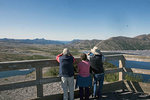
A trio of visitors to the Windy Ridge view point look out over the recovering desolation zone at the foot of Mount Saint Helens on Tuesday afternoon. A herd of 22 elk were visible loafing in the gravel outwash just to the left of the edge of Spirit Lake.
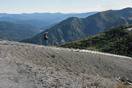
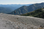
A hiker begins the decent to the parking lot at Windy Ridge within the Gifford Pinchot National Forest as Mount Hood looms in the distance. Approximately 30 people visited the view point during a two hour period on Tuesday afternoon.
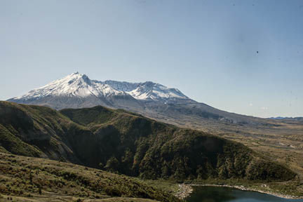
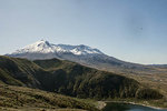
The crater of Mount Saint Helens is scene from the Windy Ridge viewpoint on Tuesday afternoon. The log strewn shore of Spirit Lake can be seen at the bottom right of the photograph.
The floating log mat of Spirit Lake, left behind after the May 18, 1980, eruption of Mount St. Helens can be clearly seen from the Windy Ridge viewpoint.
RANDLE — It’s a 36 mile drive along winding, lopsided, overgrown U.S. Forest Service Roads from the turnoff at Highway 131 in Randle to the parking lot at the Windy Ridge Viewpoint. As the forest trees fly by like oversized pickets occasional gaps in the sylvan fence reveal magnificent views of the symmetrical peaks of Mount Adams and Mount Hood. Their perfect pinnacle peaks already draped in snow, they seem to float like icebergs on a sea of evergreens.
As Forest Service Road 25 leads into FS 99, Mount St. Helens begins to make brief appearances from roadside vantage points. Unlike its well postured neighbors, Mount St. Helens seems to slump in its chair, its edges all crumbling toward the gaping maw middle and only a precious ring of snow to cover its otherwise barren rockscape. As the road climbs ever higher evidence of the mountain’s destructive force from its 1980 eruptions becomes evident at every turn. Aside from the missing lid on the mountain there are entire distant ridgelines that remain virtually denuded from the blast. The skeletons of dead trees litter the ground, each one pointed away from the blast zone like birthday cake candles blown out with gale force winds.
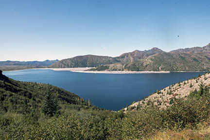
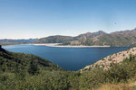
As the road makes its final approach to the Windy Ridge lookout Spirit Lake comes into view just over the shoulder to the west. It’s impressive shoreline, raised some 200 feet by the pyroclastic flows of the eruption, remains littered with downed trees. Unlike their brittle companions left to splinter in the sun and rot in the rain the logs on Spirit Lake float atop their watery grave as a memorial floatilla of sorts. A small island of logs near the west shore is said to have formed directly above the spot Harry Truman held his ground until he was buried alive by the cataclysmic flow of the disintegrating mountain.
Rounding the final corner to the Windy Ridge parking lot, Mount St. Helens finally comes into perfect focus as the road seems to deliver you midway up the mountainside with a direct view into the cavernous crater and its swelling lava dome. A 368-step wooden walkway seems to make a stairway to heaven but instead offers sightseers a direct route to a peekaboo vantage point of the rough and tumble side of the volcano. A 10-minute hike up the stairs leaves hikers winded but the views at the top still manage to take their breath away, one after the other. To the west a nearly eye-level vantage of Mount St. Helens reveals the guts of her gargantuan blowout while small puffs of steam percolate through cracks in the rock in order to vent out of the cater like a chimney from the netherworld. To the east Mount Adams sits stoic as a silent witness, just as it did on that transformative day 37 years ago, and to the north Spirit Lake sparkles in the golden autumn sun while a bleach bone forest of yesteryear quietly bobs on its surface.
On Tuesday, a trail that leads beyond the main viewpoint area and wraps around the southeast shore of Spirit Lake was closed due to washouts along the way. Another sign pleaded with visitors to stay on the designated trail in order to support glacially paced re-vegetative efforts that have been underway since that fateful day in 1980.
As I reached the crest of Windy Ridge a fully equipped hiker, complete with shock absorbent poles and steel frame backpack, was wrapping up his lunch and could soon be seen walking off into the distance all by his lonesome. Another man who arrived at the top of the lookout stairs a short time later noted that the hiker was in the midst of a loop hike from Ape Canyon, to the Plains of Abraham, to Smith Creek, and down to the Lava Canyon. That man, Bob Daugherty, said that he traveled the same loop one week prior with the aid of a mountain bike. Daugherty, from Portland, said the roughly 20 mile trek took about seven hours to complete thanks in part to a minor mix up in directions and a short stint of alternative navigation, otherwise known as being lost. On Tuesday Daugherty brought along his wife, Chris Ann, so that she could take in the awe inspiring views for herself.
“I remember when the mountain blew. Being in Portland you could feel it and then the ash started falling, but this is the first time I’ve made it to the crater,” said Chris Ann Daugherty as she soaked in the ash spackled surroundings.
Once they reached the top the Daughertys were in no rush and with their mountain bikes and travel camper stowed away in the parking lot, they said they were prepared to remain enveloped in the majesty of the high country for at least another day despite temperatures that dropped near freezing Tuesday night.
John Voigt, of Gig Harbor, was another traveler who found his way to the top of Windy Ridge on Tuesday afternoon. He said he has visited the Windy Ridge viewpoint numerous times over the years after summiting the old mountain on July 21, 1969, the same day as the first Apollo moon landing.
“We came down and we wondered if they made it,” remembered Voigt as he stared into the gaping crater of the new Mount St. Helens.
With a pair of binoculars in hand Voigt spotted a herd of 22 elk lounging about on the hot rocks of an alluvial outwash in between the base of the mountain and the edge of Spirit Lake. With the naked eye the white-butt ungulates looked just like the stumps that pockmark the scenery in every direction.
While the scenery left Voigt with nothing to be desired he was plenty disappointed in the rough condition of Forest Service roads 25 and 99.
“This road was considered one of the best rides in the state for cars and motorcycles,” said Voigt as he shook his head. “I wouldn’t do it again without a truck.”
Indeed, before leaving the spectacular vantage Voigt vowed to take FS 25 south out toward Cougar and Woodland in hopes of finding a smoother route, even though it doubled his drivetime home.
The U.S. Forest Service knows all about the road issues and the agency put in plenty of work this summer just to offer any access to Windy Ridge at all. Typically FS 99 opens sometime in early to mid-July when the winter snow accumulations melt. This year that snow didn’t melt until late July and when it did recede the vanishing snow revealed massive washouts and other damages from winter storms. Once those repairs were completed, access to Windy Ridge was finally opened up on Aug. 28.
The Forest Services says that Windy Ridge is a popular destination within the Gifford Pinchot National Forest, even though it not accessed as frequently as the Johnston Ridge Observatory to the west. That discrepancy is partially due to accessibility issues and partially attributable to the bare bones nature of the Windy Ridge route, said a U.S. Forest Service representative. While the Spirit Lake Memorial Highway route is loaded with indoor learning centers, interpretive rangers and fancy accommodations the Windy Ridge side is far more desolate. There are plenty of restrooms and information signage, but little else other than the awe inspiring remnants of an eviscerated mountainside to hold one’s attention. And that’s just fine since many visitors say that Windy Ridge provides better views of volcano country and allows for a better sense of the destruction left in the wake of the eruption.
A representative at the Cowlitz Valley Ranger Station noted that access to Windy Ridge this fall and winter will be dictated by the arrival of snowfall. The Forest Service says the road is usually closed by late November or early December. Here in the first week of October there were no signs of snow along the road and the snowline on the mountain appeared to be at least a thousand feet higher than the parking lot at Windy Ridge. However, with the recent arrival of fall, those conditions can change at any time.
Additional information on Windy Ridge can be found online at https://tinyurl.com/yc2j369s.


