A train rolls past Schaefer Park in Centralia as floodwaters from the Skookumchuck River inundates the Centralia park on Friday morning.

The South Fork of the Newaukum River rages through Onalaska on Thursday afternoon.
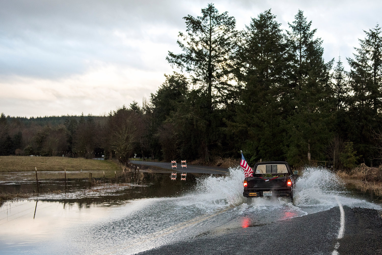
A truck drives through shallow flood waters from the Newaukum River covering a portion of Tauscher Road on Thursday afternoon north of Onalaska.
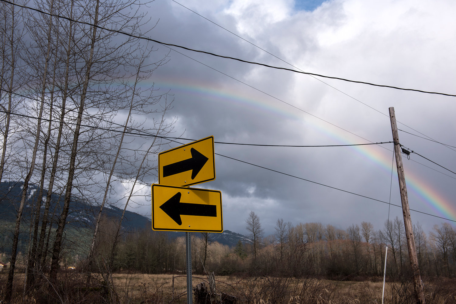
A rainbow forms in the sky above Glenoma on Thursday afternoon.

Water flows down the sides of cliffs as cars maneuver a curvy section of U.S. Highway 12 near the Mossyrock Dam on Thursday afternoon.

Cattle stand in a field as rain falls to the south while the sun pops out of the clouds in the west on Thursday afternoon in Salkum.

Dr. James Lee, a retired dentist in Chehalis, works on his swing at the soggy driving range at Newaukum Golf Course on Thursday afternoon. Dr. Lee, 85, said he was practicing for a tournament next week in Banning, Calif.
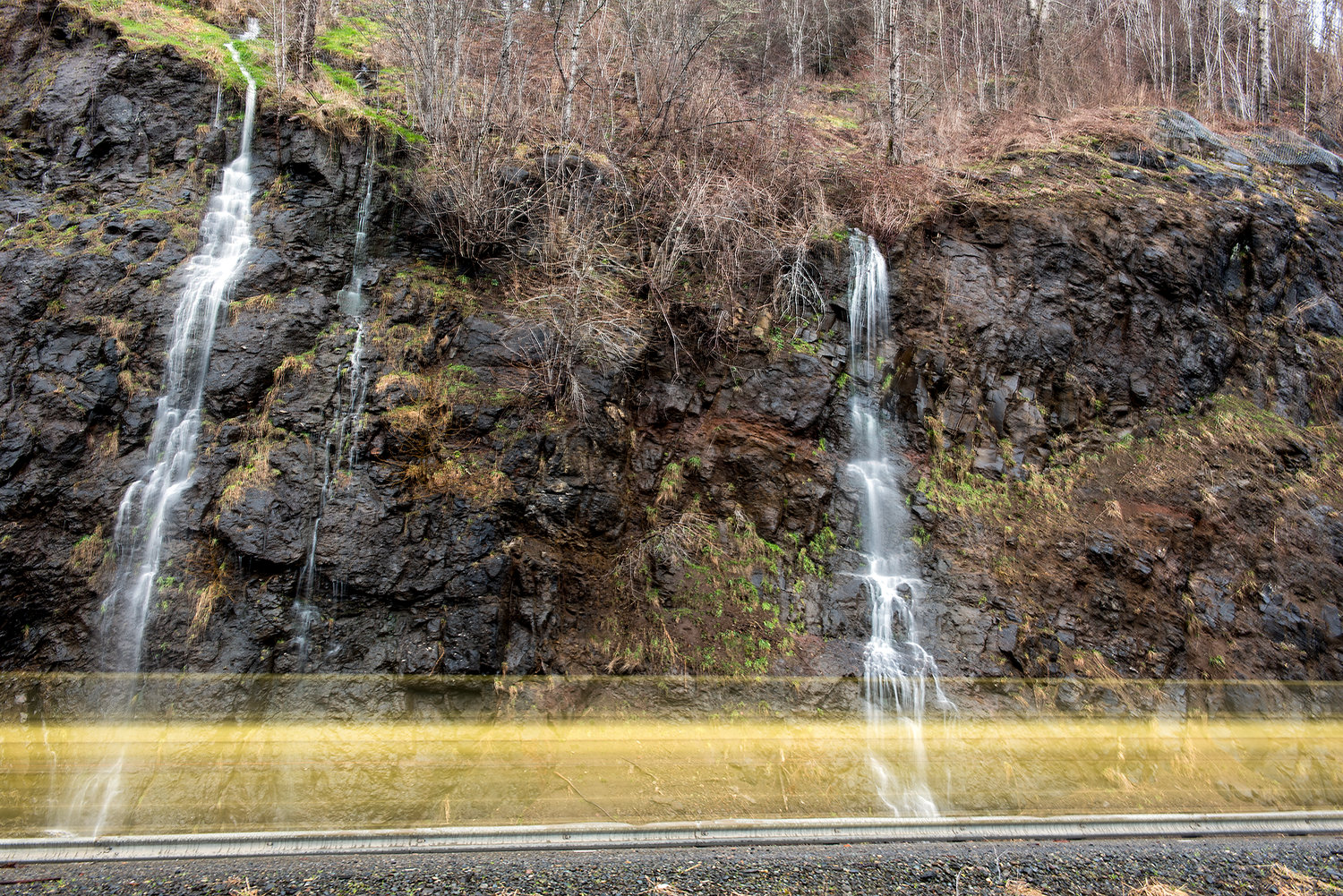
In this long exposure photo, a car whizzes by along U.S. Highway 12 as water cascades down a cliffside east of Mossyrock on Thursday afternoon.
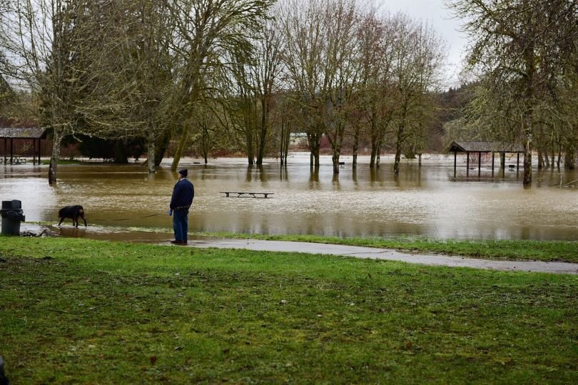
Derlyn Beagle, of Centralia, walks his dog, Brody, through a dry spot in Schaefer Park on Friday morning in Centralia.


By Aaron Kunkler and Jordan Nailon / For The Chronicle
Following heavy snow and rain over the course of the week, Lewis County largely avoided significant flooding even as the precipitation caused rivers and creeks throughout Southwest Washington to swell.
Still, there were serious reports of damage wrought by wind and slides, with a tree temporarily cutting off Pe Ell’s water supply and a mudslide closing state Route 7 outside Morton. Additionally, White Pass was closed due to an avalanche, but reopened Friday afternoon.
A winter storm on Monday brought a few inches of snow in the lowlands with as much as 30 inches accumulating in the mountains. An additional 13 to 25 inches fell in the mountains over the past two days while up to 5 inches of rain fell on Western Washington lowlands.
The rain and the melted snow sent area rivers climbing.
Power was lost in wide swaths of the county on Monday and Tuesday, which was largely restored by Wednesday.
A downed tree near Pe Ell severed a pipe that transported water to the town’s water plant and saw the town begin pulling water from the Chehalis River. However, the pumps became clogged, forcing the town to run off its reserve water supply as crews repaired the damaged pipe beginning on Thursday morning.
The water plant was eventually restarted Thursday night, and the town’s mayor said water reservoirs should be replenished at some point on Saturday.
Water over the roads in Pe Ell also prompted the closing of the school around noon on Thursday.
In East Lewis County, large bodies of standing water were reported around the Cowlitz River.
A large mudslide on Thursday near Mineral buried a portion of state Route 7 south of the town.
Washington State Department of Transportation Spokesman Bart Treece said there was significant debris that slid across the road and that a creek had been diverted and was also flowing across the pavement.
As of Friday afternoon, some 1,000 cubic yards of mud and debris has been cleared from the road, Treece said, but more work remained.
Treece said crews were working to clear culverts to redirect the stream off of the road.
In a video posted by the Lewis County Sheriff’s Office, physical damage and erosion to the road was evident, and Treece said he did not have an estimate on when the road could be reopened.
“We appreciate patience from people out there,” Treece said.
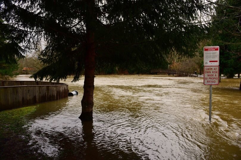
On Friday afternoon, the Skookumchuck River could be seen filling in the shallows of Schaefer County Park in Centralia.
Derlyn Beagle, of Centralia, was at the park around noon taking his 140-pound puppy dog named Brody for a walk along the flooded edge of the park.
Beagle noted that he and Brody walk the nature trail at the park nearly every day but they were unable to do so on Friday because access to the bridge was cut off by the raging river. He said it is as high as he’s seen the Skookumchuck all winter long.
Upriver, the town of Bucoda narrowly escaped a soaking.
Flooding was anticipated on city streets, but a representative from the public works department said the river crested in the late morning just shy of spilling the banks.
Portions of Galvin experienced minor flooding from the Chehalis River but no roads were closed.
However, in the Rochester area, Independence Road was closed to traffic on the east side of Helsing Junction.
Numerous cars considered braving the flooded roadway but, wisely, none took the plunge as more than 2 feet of water covered the road at its deepest section and nearly 100 feet of road was covered in fast flowing water.
Significant flooding was also visible in the Lincoln Creek valley although the road was open to motorists and no structures appeared to be threatened by the water.
China Creek in Centralia also flooded the intersection of Iron Street and West Magnolia Street on Thursday, prompting the city to shut it down and set up a sandbag station nearby.
By Friday morning, the water had receded significantly and was no longer flooding the intersection.
The Chehalis River at Doty reached minor flood stages on Thursday before rapidly receding, as did the Newaukum River at Chehalis.
The Chehalis River at Grand Mound reached the moderate flood stage on Friday afternoon and was expected to peak later in the evening before tapering off throughout Saturday.
Regional News: Passes Reopen; Heavy Rains Cause Flooding, Landslides
SEATTLE (AP) — Heavy rains have led to flooding, mud slides, power outages and the closure of mountain passes across Washington state.
A landslide destroyed a home in Maple Valley. The National Weather Service issued flood warnings for Yakima and surrounding areas.
The eastbound lanes of Interstate 90, which were closed Wednesday night because of heavy snow, opened Friday morning, while the westbound lanes reopened Friday afternoon.
U.S. 2 over Steven Pass and U.S. 12 over White Pass also reopened as of Friday afternoon after closing Wednesday.
The Washington State Department of Transportation tweeted at 3 p.m. that all three cross-state passes were back open.
"Please be safe as you head over the mountains. We appreciate your patience," the tweet said.
Tumwater Falls this afternoon.
Mudslide in Mineral, Between Morton and Elbe.
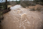
Chehalis River in Independence Valley this afternoon.
Skookumchuck River near Schaefer Park.
Chehalis Tribal Emergency Operations update:
Lincoln Creek at Teague Road Friday afternoon.
Schaefer Park in Centralia this morning.
Video of the Mineral mudslide this morning from WSDOT.
Updated emergency info for Rochester / Thurston County residents from Thurston County Emergency Management.
Chehalis Police Department reminds residents about road closures.
Heavy Rains Cause Flooding, Landslides Across Western Washington
SEATTLE (AP) — Heavy rains have led to flooding, mud slides, power outages and the closure of mountain passes across Washington state.
A landslide destroyed a home in Maple Valley. The National Weather Service issued flood warnings for Yakima and surrounding areas.
The eastbound lanes of Interstate 90, which were closed because of heavy snow, were opened on Friday morning, but the westbound lanes remained closed due to standing water, drainage issues, and debris brought down from avalanche control.
U.S. 2 over Steven Pass and Tumwater Canyon were closed overnight. Transportation officials said early Friday that there was no estimated time for reopening the road.
More rain is in the forecast throughout the day Friday.
Chehalis River at Grand Mound Continues to Rise as Others Recede
By Aaron Kunkler / akunkler@chronline.com
River levels around the region are dropping across the board, with the exception of the Chehalis River at Grand Mound, which is projected to continue rising until 6 p.m.
At Grand Mound, water levels are currently about to reach moderate flood stages, according to the National Weather Service and will peak later this evening at nearly 16.5 feet. The river will begin receding overnight. Major flooding begins at 17 feet.
Along the Skookumchuck River at Bucoda, water levels reached a high of nearly 16.23 feet overnight and have been receding, though the river still remains in a moderate flooding stage. As of 10 a.m. on Friday morning, the National Weather Service registered river depth at 15.9 feet, well below the 17-foot major flooding mark.
The Chehalis River at Centralia entered an action stage overnight and is projected to peak at 64.8 feet today, but is not anticipated to enter minor flooding stages, which occurs at 65 feet.
The Skookumchuck River in Centralia is expected to behave similarly, peaking just below the minor flood stage before receding this morning.
The Newaukum River in Chehalis experienced minor flooding yesterday and has been dramatically receding overnight, similar to the Chehalis River at Doty, which hit a high-water mark of 14.32 feet on Thursday morning.
In Centralia, China Creek overflowed yesterday, leading the city to shut down the intersection of Iron Street and West Magnolia Street and set up a sandbag station on North Pearl Street.
As of Friday morning, the intersection was not flooded and China Creek was receding.
Gauges in east Lewis County all show water levels well below action levels.
Flooding also caused problems in Pe Ell earlier this week.
A broken water pipe in the Pe Ell water system was repaired and the water processing plant was brought back online late Thursday, Pe Ell Mayor Lonnie Willey said, after the pipe was initially damaged earlier this week when a tree fell on it. This led the town to begin drawing water from the Chehalis River.
Heavy rainfall and snowmelt over the past two days dredged up sediment and caused the river pumps to become clogged with mud, Willey said.
As of 9 a.m. on Friday morning, Willey said the town had around 8 feet of water in its reserves, which is enough for roughly two days.
Willey said while the reserves will be replenished over at least the next 24 hours, residents should continue to conserve water.
Crews worked yesterday to repair the damaged pipe but a lack of water coupled with rising floodwater forced the closure of the local school around noon on Thursday.
As of Friday morning, Willey said the situation had stabilized in the town.
“The water’s running, so we’re headed the right direction, it just takes a while to catch up,” he said.
Water Pipe Repaired in Pe Ell; Mayor Asks Residents to Continue Conserving Water
A broken water pipe in the Pe Ell water system was repaired and the water processing plant was brought back online late Thursday, Pe Ell Mayor Lonnie Willey said.
As of 9 a.m. on Friday morning, Willey said the town had around 8 feet of water in its reserves, which is enough for roughly two days.
Willey said while the reserves will be replenished over at least the next 24 hours, residents should continue to conserve water.
The pipe was initially damaged earlier this week after a tree fell on it, leading the town to begin drawing water from the Chehalis River.
Heavy rainfall and snowmelt over the past two days dredged up sediment and caused the river pumps to become clogged with mud, Willey said.
Crews worked yesterday to repair the damaged pipe but a lack of water coupled with rising floodwater forced the closure of the local school around noon on Thursday.
As of Friday morning, Willey said the situation had stabilized in the town.
“The water’s running, so we’re headed the right direction, it just takes a while to catch up,” he said.
Water over the roadway at Hamilton & LaBree Roads, south of Chehalis.
Driving over the Newaukum River at the Rogers, Rice & LaBree Roads intersection.
River levels on the Chehalis River at Grand Mound are projected to come within striking distance of major flooding by tomorrow evening as the river is projected to reach a depth of 16.9 feet, one-tenth of a foot away from hitting the major flood mark.
The Skookumchuck River at Bucoda is also expected to see moderate flooding around 6 a.m. tomorrow before tapering off over the rest of the day.
Along the Newaukum River at Chehalis, stage three flooding is expected by 10 p.m. Thursday, and the river has nearly reached stage two flooding at 11.51 feet as of 3:40 p.m. on Thursday.


